Suez Canal
SUEZ CANAL INFORMATION
Historical outline
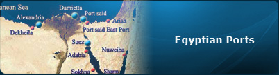
The Suez Canal is considered to be the shortest link between the east and the west due to its unique geographic location; it is an important international navigation canal linking between the Mediterranean sea at Port said and the red sea at Suez. The idea of linking the Mediterranean sea with the red sea by a canal dates back to 40 centuries as it was pointed out through history starting by the pharaohs era passing by the Islamic era until it was dredged reaching its current condition today.
It is considered to be the first artificial canal to be used in Travel and Trade. The Whole Idea of establishing a canal linking between the red sea and the Mediterranean dates back to the oldest times, as Egypt dredged the firs artificial canal on the planet’s surface. The pharaohs dredged a canal link in between river Nile and the red sea. This canal ran a while and then stopped until Muslims conquered Egypt under the leader ship of Amr-Ebn-El-Aas complying with the orders of Omar Ebn El Khattab. When the Portuguese discovered Ras El Raga El Saleh at the beginning of the 16th century the world trade movement changed making Egypt and Alexandria not considered the heart of it anymore.
After that it was Francis Delicips the one with the idea of re-dredging the Canal in (25 April, 1859) and was formally opened during the ruling of El Khedive Ismael (17 November, 1869) in a major celebration which was attended by most of Europe’s kings and Princes and the license period was 99 years from the date of opening of the canal and then it becomes after that a property of the Egyptian Government, and the French owned most of its stock.
After July 1952 Revolution, president Gamal Abd El Naser publicized the canal in announcement in (26 July, 1956) making the management of the canal a 100% Egyptian, which enraged the major countries leading to the Triad assault on Egypt in (29 October, 1956) which caused to the closing of the canal and it was reopened in (march 1957) and after that it was closed again ( 1976) due to the ships laying in the bottom of the canal and was not reopened again until (June 1975).

Stages of developing the Suez Canal
The dredging of the canal took almost 10 years using Egyptian labor, and it was opened for navigation for the first time in 17 November, 1869. Its depth was about 8 meters, its water are was 304 m2 and the largest ship load that can pass through was 5000 tons, which was typical for ships sizes in these days. As the ships developed and increased its sizes, the canal needed to be developed, which happened when it was still a foreign joint venture before being publicized to take ships with depth of 35 feet and its water area to be 1100 m2 by the end of 1956 and when the canal was publicized by the Egyptian government on the 26th of July, 1956.
Navigation canal even more on different stages
In May 1962, the water area of the canal was to reach 1800 m2 and the allowed depth to 38 feet. In June 1966, a development was to be executed on 2 stages as it was announced the depth would reach 48 and 58 feet consecutively. This program was started in February 1962, but was soon halted due to the war that erupted on the 5th of June, 1967. It was reopened for international; navigation in June 1975 after purifying it from the ships that sank in its bottom during in the 1962 and 1973 wars with the same water area and depth before it was closed. The development projects then started by the Egyptian administration in order to receive ships of a 210,000 tons load, specially after increasing the water are to 4800 m2 and a depth of 62 feet , with a length of 190.25 km, in addition to the redesign of the canal's turns so that each one has a half radius of at least 5000 m and also dredging a new verge starting from the 17th km south of port said heading directly to the Mediterranean east of port Fouad to allow the loaded ships going north to go to the sea without passing through port said port. The Suez canal is distinguished by its stable level of water which varies very slightly having the highs tide reaching 50 cm in the north while reaching up to 2 m in the south.
Traffic System
The Canal is run in a convoy system allowing ships to transit as fixed speed and a fixed separation distance between every two passing ships, Three convoy pass through the Canal every day, two southbound against one northbound. Each of the three convoys follows a certain system as for the time of entering the Canal, the speed limits and the emergency stopping distance between every two ships within the one convoy.
Current state for year 2007 - 2006 - 2005 - 2004
Current state for year 2007
| Total number of vessels calling at Suez Canal | 20384 ship |
|---|---|
Net Tonnage |
844.4 million Ton |
Container Vessels |
7718 ship |
Net Tonnage of Container Vessels |
437806 Thousand Ton |
Cargo volume from North to South |
286028 Thousand Ton |
Cargo volume from South to North |
424047 Thousand Ton |
Total cargo volume |
700.027 million Ton |
Containerized cargo from North to South |
141381 Thousand Ton |
Containerized cargo from South to North |
177107 Thousand Ton |
Total of Containerized cargo |
318488 Thousand Ton |
The position of the Suez Canal for year 2006
| Total number of vessels calling at Suez Canal | 18664 ship |
|---|---|
Net Tonnage |
742.7 million Ton |
Container Vessels |
6974 ship |
Net Tonnage of Container Vessels |
366549 Thousand Ton |
Cargo volume from North to South |
252215 Thousand Ton |
Cargo volume from South to North |
376420 Thousand Ton |
Total cargo volume |
628.6 million Ton |
Containerized cargo from North to South |
126082 Thousand Ton |
Containerized cargo from South to North |
150817 Thousand Ton |
Total of Containerized cargo |
276899 Thousand Ton |
The position of the Suez Canal for year 2005
| Total number of vessels calling at Suez Canal | 18193 ship |
|---|---|
Net Tonnage |
671782 Thousand Ton |
Container Vessels |
6557 ship |
Net Tonnage of Container Vessels |
321302 Thousand Ton |
Cargo volume from North to South |
244836 Thousand Ton |
Cargo volume from South to North |
326269 Thousand Ton |
Total cargo volume |
571105 Thousand Ton |
Containerized cargo from North to South |
119006 Thousand Ton |
Containerized cargo from South to North |
128130 Thousand Ton |
Total of Containerized cargo |
247136 Thousand Ton |
The position of the Suez Canal for year 2004
| Total number of vessels calling at Suez Canal | 16850 ship |
|---|---|
Net Tonnage |
621230 Thousand Ton |
Container Vessels |
5928 ship |
Net Tonnage of Container Vessels |
284307 Thousand Ton |
Cargo volume from North to South |
211563 Thousand Ton |
Cargo volume from South to North |
309427 Thousand Ton |
Total cargo volume |
520990 Thousand Ton |
Containerized cargo from North to South |
108341 Thousand Ton |
Containerized cargo from South to North |
112038 Thousand Ton |
Total of Containerized cargo |
220379 Thousand Ton |
Totals of Suez Canal
| 2001 | 2002 | 2003 | 2004 | 2005 | 2006 | 2007 | |
|---|---|---|---|---|---|---|---|
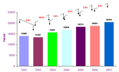
Total Crossing Vessels (Vessel) |
13986 | 13447 | 15667 | 16850 | 18193 | 18664 | 20384 |
| 3.85% | 16.51% | 7.55% | 7.9% | 2.41% | 9.22% | ||
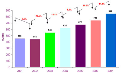
Net Tonnage (million tons) |
456.1 | 444.8 | 549.4 | 621.2 | 671.8 | 742.7 | 848.2 |
| 2.48% | 23.52% | 13.07% | 8.15% | 10.55% | 14.20% | ||
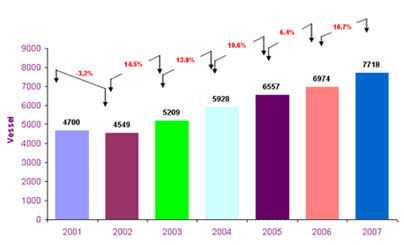
Number of Containers (Vesel) |
4700 | 4549 | 5209 | 5928 | 6557 | 6974 | 7718 |
| 3.21% | 14.51% | 13.80% | 10.61% | 6.36% | 10.67% | ||
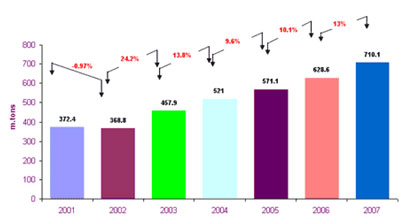
Total Cargo Volume (million tons) |
372.4 | 368.8 | 457.9 | 521 | 571.1 | 628.6 | 710.1 |
| 0.97% | 24.16% | 13.78% | 9.62% | 10.07 | 12.97 |
Net Tonnage of Vessels Transiting Suez Canal During 2001-2007
Number of Vessels Transiting Suez Canal During 2001-2007
Number of Container Vessels Transiting Suez Canal During 2001-2007
Volumes of Cargo Transiting Suez Canal During 2001-2007
The Suez Canal has been doubled in four parts (78 Km.), and this allows the transit of ships in both directions:
1. Port Said by-pass 36.5 km. accomplished in 1980
2. Ballah by-pass 9 km. accomplished in 1955
3. Timsah by-pass 5 km. accomplished in 1980
4. Deversoir by-pass 27.5 km. accomplished in 1980
It is worth mentioning that the more doubled parts the Canal has, the less transit time ships shall have and the more their number will be.
The Suez Canal pilots are credited with piloting ships from the time they arrive at the roadsteads till they exit at the other end of the Canal to the open sea.
It takes the ship from 12 to 16 hours to transit the Canal. The numerical capacity of the Canal is about 76 standard ships per day.
Characteristics
| Item | Unit | 1869 | 1956 | 1962 | 1980 | 1994 | 1996 | 2001 | 2008 |
| Overall Length | Km. | 164 | 175 | 175 | 190.25 | 190.25 | 190.25 | 190.25 | 190.25 |
| Doubled Parts | Km. | - | 29 | 29 | 78 | 78 | 78 | 78 | 78 |
| Width at 11 m. depth | m. | 44 | 60 | 90 | 160 | 180/210 | 180/210 | 200/210 | 210 |
| Water depth | m. | 10 | 14 | 15.5 | 19.5 | 20.5 | 21 | 22.5 | 23.5 |
| Max. Draft of Ship | Feet | 22 | 35 | 38 | 53 | 56 | 58 | 62 | 68 |
| Cross Sectional Area | m2 | 304 | 1100 | 1800 | 3600 | 3800/4300 | 3900/4500 | 4800 | 4800 |
| Max. Tonnage (DWT) | Ton | 5000 | 30.000 | 80.000 | 150.000 | 180.000 | 185.000 | 210.000 | 210.000 |
Influence of the Suez Canal on World Trade
The geographical position of the Suez Canal makes it the shortest route between East and West as compared with the Cape of Good Hope. The Canal route achieves a saving in distance between the ports north and south the Canal, the matter that is translated into other savings in time, fuel consumption and ship operating costs as show in the table below
| From | To | Distance (N. Miles) | Saving % | |
|---|---|---|---|---|
| S.C. | CAPE | |||
| Ras Tanura | Constantza | 4.144 | 12.094 | 66 |
| Lavera | 4.684 | 10.783 | 57 | |
| Rotterdam | 6.436 | 11.169 | 42 | |
| New York | 8.281 | 11.794 | 30 | |
| Jeddah | Piraeus | 1.320 | 11.207 | 88 |
| Bombay | Rotterdam | 6.337 | 10.743 | 41 |
Contacts
| Head Office | Irshad Building - Ismailia |
|---|---|
| Chairman | Ahmed Aly Fadel |
| Tel | (064) 30/3910000 |
| Fax | (064) 3914784 - 3914784 |
| scanalb@idsc.net.eg | |
| code | Ismailia (41515) |
| Port Said (42533) | |
| Suez (43522) | |
| Alexandria (21561) | |
| Port Fouad (42524) | |
| Cairo (11511) |